1832 Burr Map of France in Departments 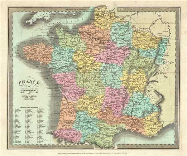 WE SELL ONLY ORIGINAL ANTIQUE MAPS - NOT REPRODUCTIONS Title: France in Departments. Description: This beautiful first edition map of France was issued by David Burr in 1832. It depicts the Kingdom of France showing its various departments. Towns, river, mountains and various other important topographical details are noted. Elevation throughout is rendered by hachure. A reference to the departments is included in the lower left quadrant. Until 1790 France was divided into 40 provinces based on local loyalties and feudal histories. On March 4th of 1790 the National Constituent Assembly reorganized the Provinces with what the Assembly deemed a more rational political structure. The new department system was intended to deliberately break up Frances historical regions in an attempt to erase cultural differences and build a more homogeneous nation. Initially there were 83 departments but by 1800 that number increased to roughly 130, of which 84 are listed here. Many of the departments that were created in 1790 remain administrative districts to this day. According to Ristow, although Burr is credited on the title page, he left this atlas incomplete. He was appointed as topographer to the U.S. Post Office, and of the sixty-three maps finally included in this atlas, only completed eight. The rest of the maps were then completed by Illman and Pilbrow in Burrs style. The map was ‘Entered according to act of Congress in the year 1832 by David H. Burr in the Clerk’s office of the District Court for the Southern District of New York’, but not published until the atlas was released in 1835. Published by D. S. Stone in Burr’s New Universal Atlas. Size: Printed area measures 11.5 inches high by 13.5 inches wide. Condition: Very good. Minor foxing. Original platemark visible. Minor edge wear. Shipping: Shipping rates are not negotiable. Items are shipped within three business days of receiving payment. We are happy to consolidate shipping where possible. The following shipping options are available: 1. FedEx Overnight (45 USD). USA Only. Signature Required. Customs: International buyers are responsible for paying duty and taxes on delivery. DHL or FedEx will contact the buyer by telephone to arrange tax payment if it is levied. Duty varies by country and we cannot predict the amount you will be charged. Some countries are duty free, others are not. Typically, a customs duty and/or VAT tax will be assessed on all parcels to continental Europe. Sometimes duty or tax is due in China, but is seems very random. Hong Kong, Singapore, Korea, and Taiwan have never assessed duty on a map we shipped. Maps shipped to the UK should be duty free as educational materials, but from time to time duty of 5% is assessed incorrectly by the UK customs agents. Insurance: All shipments are insured privately against loss and damage. All of our shipments require a signature for insurance purposes. If you have any questions please feel free to email us through eBay. Other Services Conservation Framing: Geographicus recommends basic conservation framing services for any antique paper. We do not offer this service. |

" class="zoomMainImage swiper-slide">
1832 Burr Map of France in Departments WE SELL ONLY ORIGINAL ANTIQUE MAPS - NOT REPRODUCTIONS Title: France in Departments. Description: This beautiful first edition map of France was issued by David Burr in 1832. It depicts the Kingdom of France showing its various departments. Towns, river, mountains and various other important topographical details are noted. Elevation throughout is rendered by hachure. A reference to the departments is included in the lower left quadrant. Until 1790 France was divided into 40 provinces based on local loyalties and feudal histories. On March 4th of 1790 the National Constituent Assembly reorganized the Provinces with what the Assembly deemed a more rational political structure. The new department system was intended to deliberately break up Frances historical regions in an attempt to erase cultural differences and build a more homogeneous nation. Initially there were 83 departments but by 1800 that number increased to roughly 130, of which 84 are listed here. Many of the departments that were created in 1790 remain administrative districts to this day. According to Ristow, although Burr is credited on the title page, he left this atlas incomplete. He was appointed as topographer to the U.S. Post Office, and of the sixty-three maps finally included in this atlas, only completed eight. The rest of the maps were then completed by Illman and Pilbrow in Burrs style. The map was ‘Entered according to act of Congress in the year 1832 by David H. Burr in the Clerk’s office of the District Court for the Southern District of New York’, but not published until the atlas was released in 1835. Published by D. S. Stone in Burr’s New Universal Atlas. Size: Printed area measures 11.5 inches high by 13.5 inches wide. Condition: Very good. Minor foxing. Original platemark visible. Minor edge wear. Shipping: Shipping rates are not negotiable. Items are shipped within three business days of receiving payment. We are happy to consolidate shipping where possible. The following shipping options are available: 1. FedEx Overnight (45 USD). USA Only. Signature Required. Customs: International buyers are responsible for paying duty and taxes on delivery. DHL or FedEx will contact the buyer by telephone to arrange tax payment if it is levied. Duty varies by country and we cannot predict the amount you will be charged. Some countries are duty free, others are not. Typically, a customs duty and/or VAT tax will be assessed on all parcels to continental Europe. Sometimes duty or tax is due in China, but is seems very random. Hong Kong, Singapore, Korea, and Taiwan have never assessed duty on a map we shipped. Maps shipped to the UK should be duty free as educational materials, but from time to time duty of 5% is assessed incorrectly by the UK customs agents. Insurance: All shipments are insured privately against loss and damage. All of our shipments require a signature for insurance purposes. If you have any questions please feel free to email us through eBay. Other Services Conservation Framing: Geographicus recommends basic conservation framing services for any antique paper. We do not offer this service. |
" alt="1832 en ligne Burr Map of France in Departments" width="527" height="527" />

1832 en ligne Burr Map of France in Departments
1832 en ligne Burr Map of France in Departments, 1832 Burr Map of France in Departments bien
€246.35
SKU: 956409
Colour
"
1832 Burr Map of France in Departments
WE SELL ONLY ORIGINAL ANTIQUE MAPS - NOT REPRODUCTIONS
Title: France in Departments.
Description: This beautiful first edition map of France was issued by David Burr in 1832. It depicts the Kingdom of France showing its various departments. Towns, river, mountains and various other important topographical details are noted. Elevation throughout is rendered by hachure. A reference to the departments is included in the lower left quadrant.
Until 1790 France was divided into 40 provinces based on local loyalties and feudal histories. On March 4th of 1790 the National Constituent Assembly reorganized the Provinces with what the Assembly deemed a more rational political structure. The new department system was intended to deliberately break up Frances historical regions in an attempt to erase cultural differences and build a more homogeneous nation. Initially there were 83 departments but by 1800 that number increased to roughly 130, of which 84 are listed here. Many of the departments that were created in 1790 remain administrative districts to this day.
According to Ristow, although Burr is credited on the title page, he left this atlas incomplete. He was appointed as topographer to the U.S. Post Office, and of the sixty-three maps finally included in this atlas, only completed eight. The rest of the maps were then completed by Illman and Pilbrow in Burrs style. The map was ‘Entered according to act of Congress in the year 1832 by David H. Burr in the Clerk’s office of the District Court for the Southern District of New York’, but not published until the atlas was released in 1835. Published by D. S. Stone in Burr’s New Universal Atlas.
Size: Printed area measures 11.5 inches high by 13.5 inches wide.
Condition: Very good. Minor foxing. Original platemark visible. Minor edge wear.
Shipping: Shipping rates are not negotiable. Items are shipped within three business days of receiving payment. We are happy to consolidate shipping where possible. The following shipping options are available:1. FedEx Overnight (45 USD). USA Only. Signature Required.
2. FedEx Ground or Home Delivery (15 USD). USA Only. 1 - 10 days. If your address is a P.O. Box and cannot ship FedEx we will ship USPS Priority and, while we ship promptly, recent postal personnel cutbacks mean that delivery may take time. Signature Required.
3. FedEx International or DHL International EXPRESS (45 USD).
4. We can use your FedEx Account.
Customs: International buyers are responsible for paying duty and taxes on delivery. DHL or FedEx will contact the buyer by telephone to arrange tax payment if it is levied. Duty varies by country and we cannot predict the amount you will be charged. Some countries are duty free, others are not. Typically, a customs duty and/or VAT tax will be assessed on all parcels to continental Europe. Sometimes duty or tax is due in China, but is seems very random. Hong Kong, Singapore, Korea, and Taiwan have never assessed duty on a map we shipped. Maps shipped to the UK should be duty free as educational materials, but from time to time duty of 5% is assessed incorrectly by the UK customs agents.
Insurance: All shipments are insured privately against loss and damage. All of our shipments require a signature for insurance purposes.
If you have any questions please feel free to email us through eBay.
Other ServicesConservation Framing: Geographicus recommends basic conservation framing services for any antique paper. We do not offer this service.
Antique Map Restoration: Geographicus can repair and restore your antique map. Services include deacidification cleaning flattening and backing.
BEWARE anyone attempting to contact you, from a different eBay account, claiming to represent Geographicus Antique Maps. My eBay handle is GeographicusMaps. If you are contacted by email by someone offering you my items, please call me directly to be certain you are not dealing with a con artist." alt="1832 en ligne Burr Map of France in Departments" width="52" height="52" >
Personalised:: ( x )Personalisation:EditRemove PersonalisationAvailable From:
Buy now.
Pay later.
Earn rewards
Representative APR: 29.9% (variable)
Credit subject to status. Terms apply.
Missed payments may affect your credit score
FrasersPlus
Available Products
SIMILAR ITEMS
- 1832 Burr Map of France in Departments
- SKF VKMA 65208 Jeu de courroies nervurées en V pour HYUNDAI
- Rot Leder Maßstab Muster 50cm x 100cm Qualität Premium Basteln Textil DSG1
- Moulinet toupie Shimano Stefano SS 100HG occasion petit bateau de pêche
- Couverture Shimon Peres Visite du Président Israël en Argentine avec Original Signé 2009 !!
- Carafe gravée en cristal de Baccarat modèle5
- Perrier Jouet Belle Epoque 2013
- PEUGEOT 405 MI16 SUPER TOURISME #1 AIELLO 1995 OTTOMOBILE OT364 1:18 2500 PCS
- Alternateur BV PSH Générateur pour MERCEDES-BENZ CLK Cabriolet A208 200
- Insigne de fonction: Conseil Général de la Seine, or/argent, Paul Brandt.
Back to top